Land for Trees and Cycleways
 |
| Johnston St, Annandale in 1800s (Wikimedia) |
 |
| Chester St, Annandale |
We need to make better use of our road reserve to provide underutilised land for pedestrians, public transport, trees, vegetation and cycleways.
 |
| Pyrmont Bridge Road |
Trees
19thCentury photos of Annandale on the verge of Johnston St. But by federation shoulder trees appeared in Haberfield and subsequently elsewhere. The trees planted on the shoulder of the road, predate the rise of cars, bitumen and concrete.
"The idea I think was that the trees were for a canopy that you would walk under and that is why they are planted in the shoulder of the road, so that one half goes over the road and the other half goes over the footpath" - The garden suburb: a conversation with Vincent Crow By: Ilaria Vanni Category: Home Gardens of Haberfield, 21st Century https://www.mappingedges.org/projects/home-gardens-of-haberfield/vincent-crow-garden-suburb/
Water Sensitive Urban Design
The Camber of the road, means water runs off to the top of the road and is available to trees and vegetation, before it runs into the gutter and out to natural creeks and rivers to the sea.
 |
Crowning, also known as camber, involves raising the centre of the road profile 150–300 mm above the table drain or natural
surface so that water drains from a high point in the centre to both sides of the road (Figures 4 and 5). Correct crowning
reduces the chance of potholes and rutting and reduces the frequency in which re-sheeting and routine grading is required."...Erosion and sediment control on unsealed roads, A field guide for erosion and sediment control maintenance practices, 2012 https://www.environment.nsw.gov.au/-/media/OEH/Corporate-Site/Documents/Water/Water-quality/erosion-sediment-control-unsealed-roads-field-guide-120410.pdf
Cycle Ways
 |
Pyrmont Bridge Road
Still in Development is the Pyrmont Bridge dedicated cycle lanes. This Road is mostly in City of Sydney However, the stretch between Mallet St and Parramatta Road is in Inner West Council where the cycle lanes were a part of the Parramatta Urban Renewal (PRUAIP, now split into Tech Central) and Westconnex Plans on closing of the adjacent Dive Site. |
| Pyrmont Bridge Road, Annandale - Westconnex Dive Site |
 |
| Chester St at Pyrmont Bridge Rd |
PRUAIP-New cycleway from Parramatta Rd to Mallet St
PRUAIP Objective
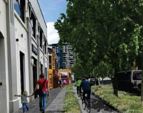 | ||
| Artist impression of new cycleway |
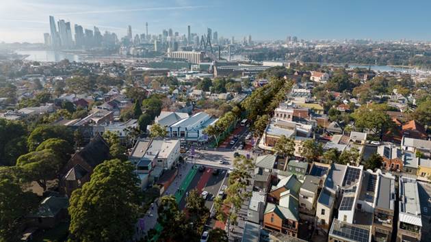 |
Figure 5: Photomontage of the
proposed changes to Victoria Road looking east to the City. (draft master plan) |
Inner West Council Transport Asset Management Plan (TAMP)
"The purpose of this Transport Asset Management Plan (TAMP) is to inform Inner West Council’s (Council) commitment to best practice asset management and provide principles for sound asset investment decision making in its transportation network.
The TAMP documents the overall integrated planning framework to guide and improve Council’s long-term strategic management of its roads, paths, kerbs, bridges, traffic management devices and street furniture in order to cater for the community’s required levels of service into the future as detailed in Section 3.6 Level of Service....
Road Transport (Safety and Traffic Management) Act 1999
Facilitates the adoption of nationally consistent road rules in
NSW, the Australian Road Rules. It also makes provision for
safety and traffic management on roads and road related areas
including alcohol and other drug use, speeding and other
dangerous driving, traffic control devices and vehicle safety
accidents...
Roads Act 1993
Sets out rights of members of the public to pass along public roads, establishes procedures for opening and closing a public road, and provides for the classification of roads. It also provides for declaration of the RTA and other public authorities as roads authorities for both classified and unclassified roads, and confers certain functions (in particular, the function of carrying out roadwork) on the RTA and other roads authorities. Finally it provides for distribution of functions conferred by this Act between the RTA and other roads authorities, and regulates the carrying out of various activities on public roads."...
Source: Page 29 of 52, Transport Asset Management https://www.innerwest.nsw.gov.au/ArticleDocuments/1490/Asset%20Management%20Plan%20-%20Transport%202022-32.pdf.aspx
Condition Assessment Report, Inner West Council https://www.innerwest.nsw.gov.au/ArticleDocuments/1882/2018%2008%20IWC%20-%20Condition%20Assessment%20Report%20-%20Final%20V1.1.docx.aspx


Comments
Post a Comment