Please Make a Submission Today to Modification to Plans for the Crescent Annandale (submissions close 13 May 2020)
There are many problems with this latest proposal from Transport NSW for the Crescent Annandale
The
increase surface roads will bring more traffic to the Crescent and
Johnston Street Annandale. This will cut Annandale Residents off from
the Foreshore and the ANZAC bridge cycle route into the city. With so
little open space in the
Inner West, connectivity is critically important to linking our open
space together.
-the revised plans of The Crescent overpass have removed a vital proposed pedestrian and cycle “horseshoe bridge” that crosses the City West link
-the road crescent road overpass (flyover).
The importance of being able to access and enjoy outdoor spaces has been especially evident during the COVID lockdown. We need to be increasing the connectivity of open space to make the most of this precious resource. The visual impact of the pedestrian horseshoe bridge is minor in comparison to the impact of the proposed road overpass.
WestConnex - M4-M5 Link MOD 2 - The Crescent overpass and active transport links Constructing a grade separated vehicular overpass comprising a two-lane east-bound flyover separating the at-grade intersection at The Crescent and City West Link and relocation of the Rozelle Rail Yard Pedestrian and Cycling Green Link.
Assessment Type SSI Modifications Development Type Road transport facilities
Exhibition Start 29/04/2020 Exhibition End 13/05/2020
More information and make submissions at https://www.planningportal.nsw.gov.au/major-projects/project/16516
The latest proposal will force people on foot, bicycles, with prams, dogs and children to cross a wide, busy road which:
- · Will see all pedestrians, dog walkers and cyclists crammed into a tiny space on the corner of Johnston Street and The Crescent as they wait to cross.
- · Forces everybody to wait up to 90 seconds for the light change – with everyone bunching up and not able to spread out.
- · Means that you need to cross a busy six-lane road rather than seamlessly and safely going up and over a pedestrian bridge.
- · Makes it very difficult to physically distance yourself from other pedestrians.
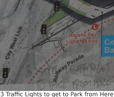
We would also like Transport for NSW to make improvements to the connection between Railway Parade and Rozelle Bay. Mums with prams, kids on bikes and the elderly who want to use a level connection to the Glebe foreshore, will now need to cross three traffic lights via the City West link.
We want Transport for NSW to remove the down-ramp beside the mural and reinstate the pedestrian footpath that provides a direct link to the Bay. The Contractor appears to have started constructing this ramp - even claiming it is part of the approved EIS.
Other comments to make in your submission:
Please take 10 minutes to write a submission objecting to the loss of pedestrian connectivity at https://www.planningportal.nsw.gov.au/major-projects/project/16516Remember – you don’t have to be an expert to make a submission! The more detail you include about how this proposal will impact you, your family and your neighbourhood the better.
WestConnex - M4-M5 Link MOD 2 - The Crescent overpass and active
transport links Constructing a grade separated vehicular overpass
comprising a two-lane east-bound flyover separating the at-grade
intersection at The Crescent and City West Link and relocation of the
Rozelle Rail Yard Pedestrian and Cycling Green Link.
Assessment Type SSI Modifications Development Type Road transport facilities
Exhibition Start 29/04/2020 Exhibition End 13/05/2020
More information and make submissions at https://www.planningportal.nsw.gov.au/major-projects/project/16516


Comments
Post a Comment